Our Eiger Trail begins in the famed resort village of Gstaad and finishes in the chalet-studded hamlet of Grindelwald, Switzerland. The primary advantage of this west-to-east itinerary is that hikers walk toward, rather than away from, the most stunning peaks of the region. In short, the famed Jungfrau region of Switzerland grows larger as each day unfolds.
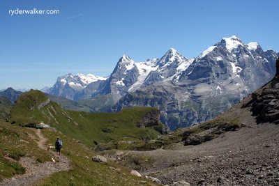
In this picture, Kristen wanders the high alpine trails above Mürren, Switzerland. This hike begins on the doorstep of our tranquil mountain house in Griesalp (1440 m), climbs over the Sefinenfurgge (2612 m), then descends via the Rotstockhütte (2030 m). A long descent to Mürren (1650 m) offers views like this one, with the Eiger, Mönch and Jungfrau peaks dominating the skyline.
Looking from left to right: The first pointed peak is the Eiger. Notice the dramatic north face (Eigernordwand) dropping precipitously on the left hand side of the peak. The ridge at the bottom of the face is called the Kliene Scheidegg.
The high, glacier-covered ridge connecting the Eiger and the Mönch (next peak to the right), is called the Jungfraujoch. The Jungfraujoch rail station sits up there and, at 3454 meters (11,322 ft), is the highest rail station in Europe.
Kliene Scheidegg is the last staging point for trains en route to the Jungfraujoch. Upon leaving Kleine Scheidegg, the trains ascend, via tunnels, the inside of the Eiger.
Tours that explore this region:




Comments are closed.