Italy | Italian Lakes District: Lake Como to Varenna
Explore Lake Como’s mountain trails and lakeside villages.


Trip Highlights:
-
Explore the famous lakeside villages of Como, Lenno, Bellagio, Menaggio, and Varenna
-
Stunning views of the Alps, including Monte Rosa (15,203 feet), the highest mountain in Switzerland and the second highest peak in Western Europe.
-
Hiking along ancient roads to hilltop churches, medieval villas and mountain huts serving delicious Italian specialities.
Lake Como’s elegant villas, Italian cuisine and colorful waterfront villages are only part of its appeal. Above the lake, a network of trails leads through chestnut forests, open meadows and rugged mountain ridges. Our Lake Como self-guided hiking tour pairs panoramic day hikes with distinctive accommodations and time to enjoy life along the shores of one of Italy’s most beautiful lakes.
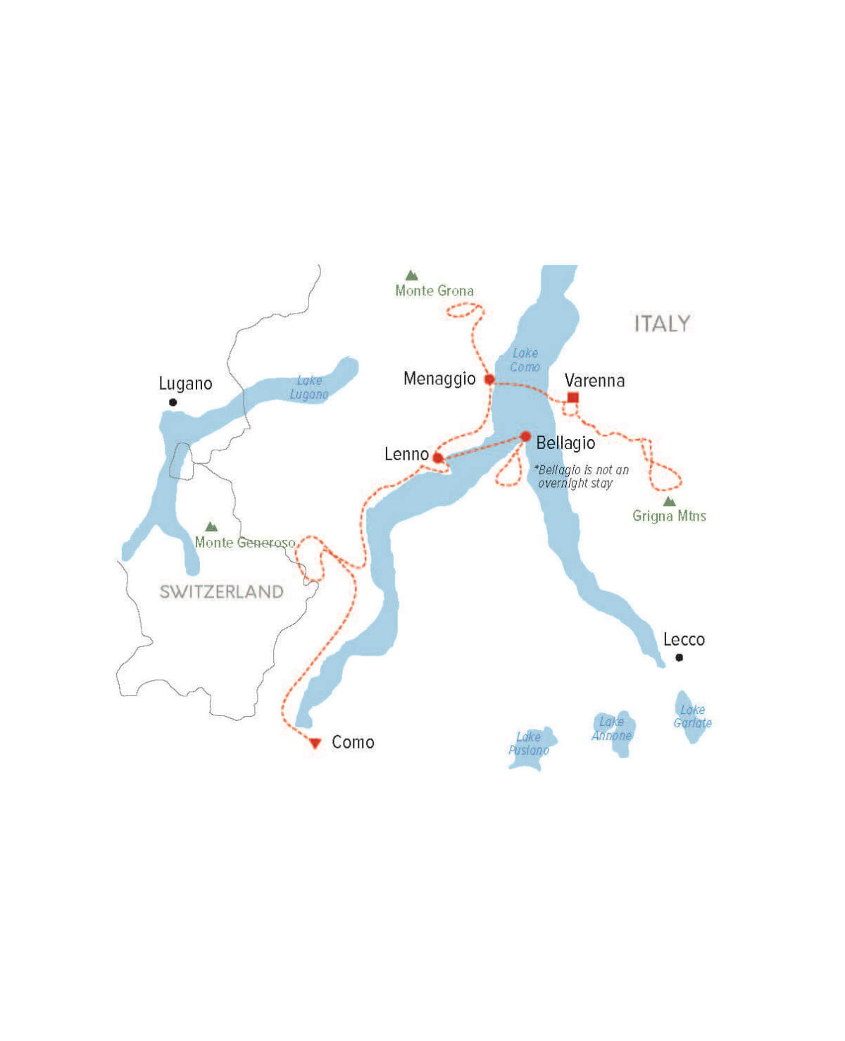
Begin in Como, where historic streets and lively piazzas introduce you to the region’s rich culture. Continue to Lenno, Menaggio and Varenna, exploring a different stretch of the lake from each town. Scenic ferry crossings and private transfers connect your journey, bringing you from the waterfront to mountain trailheads and back to your lakeside hotel.
Hike to Monte Generoso on the Italian-Swiss border, explore the cobbled lanes and wooded hills above Bellagio, and follow paths through villages along the Lago di Como Greenway. Higher trails reveal the dramatic landscape of the Grigna Massif and far-reaching Alpine views. Finish in Varenna, where pastel-colored houses, narrow lanes and a waterfront promenade provide a memorable setting for your final evening.
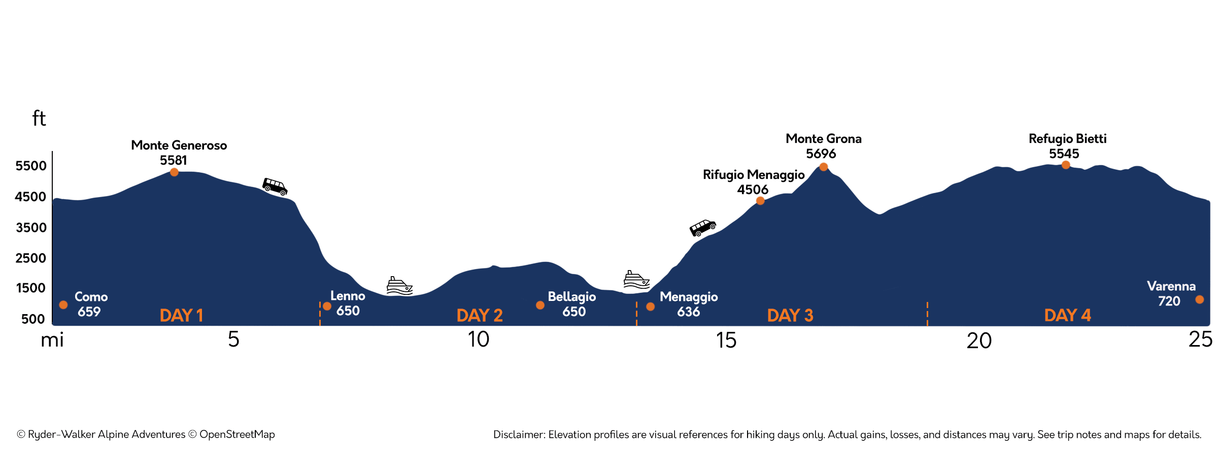
Trip Elevation
Trip Itinerary
Choose from our standard itinerary or customize the trek by adding or subtracting days.
Arrive in the lively city of Como, a cultural hub at the southern end of its namesake lake. After settling in, enjoy a stroll along the waterfront and views of the Alps above Lake Como—a glimpse of the landscapes you’ll explore in the days ahead.
Today begins with a scenic transferr to Baita di Orimento, a mountain restaurant and trailhead high in the hills above Lake Como. From here, hike through open meadows and forests toward Monte Generoso, whose summit straddles the Italian-Swiss border between Lakes Como and Lugano. Along the way, expansive ridge views unfold, with the chance to spot the free-roaming Bisbino horses. Continue beneath dramatic rock walls to reach the summit, where clear skies reveal the distant peaks of the Matterhorn, Mont Blanc and Monte Rosa. Stop for lunch near the summit or descend to Orimento for an Italian meal. Afterward, meet your driver for the transfer to the lakeside village of Lenno.
Distance: 6.5 miles. Elevation gain/loss: 1450 ft.
Two routes offer distinct perspectives on Lake Como today. For a leisurely lakeside day, begin with a visit to Villa Balbianello, where an elegant residence and terraced gardens occupy a wooded promontory overlooking the lake. Then follow the Lago di Como Greenway through historic villages and past waterfront villas before taking a bus to the picturesque resort town of Menaggio.
For a longer hike, board a ferry to Bellagio, where cobbled lanes and inviting shops lead away from the waterfront. From town, climb through chestnut forests to the panoramic terrace at Baita Belvedere, a lovely setting for an Italian lunch with sweeping views across the lake to the Alps beyond. After lunch, descend to Bellagio and catch a ferry to Menaggio and your elegant lakeside hotel.
Lago di Como Greenway–Distance: 5.5 miles. Elevation gain/loss: 800 ft.Bellagio Hike–Distance: 7 miles. Elevation gain/loss: 1750 ft.
Begin with a transfer to Breglia, a small village perched in the hills above Menaggio. From here, climb to Rifugio Menaggio for a lunch of regional Italian cuisine with sweeping views of Lake Como and the surrounding Alps. For a longer hike, continue to the summit of Monte Grona. After descending to Menaggio, board a ferry for the crossing to Varenna, where colorful houses line the waterfront beneath steep wooded hills.
Distance: 5 miles. Elevation gain/loss: 2300 ft.
Optional extension: 6 miles. Elevation gain/loss 3400 ft. Level 3 effort and terrain.
Today’s hike explores the dramatic high alpine landscape of the Grigna Massif. Traverse beneath the Piancaformia ridge to Rifugio Bietti, where lunch comes with sweeping mountain views. For a more demanding return, climb to Bocchetta Guzzi above the refuge. At the end of your hike, meet your driver for the transfer back to your hotel and a final evening in Varenna.
Distance: 6 miles. Elevation gain/loss: 1500 ft.
Optional extension: 7 miles. Elevation gain/loss: 1970 ft. Level 3 effort and terrain.
Trip Rating
COMFORT
EFFORT
TERRAIN
Self-Guided Tour
May-October
Pricing
$4,700 per person double
Single (+$1800)
Traveling solo? Please contact us for pricing.
Private Guided Tour
May-October
Please contact us to schedule a private guided tour.
Trip Map
Trip Profile
Duration
5 nights/6 days
Hiking up to 7 miles
Ascents up to 2300 ft. (with optional extension up to 3400 ft.)
Tour Package Includes
Luggage transfers
Custom route descriptions
GPX tracks for each hike
Four-color topo maps
Travel instructions
Cultural information and more
Accommodations
5 nights in luxury, and lake side boutique hotels.
Breakfast + Dinner
Breakfast daily.
Luggage Transfer
Luggage transfers are included daily.
Transportation
Taxi transfers listed on the standard itinerary are included during the tour between Como and Varenna. Public transportation costs are not included in the trip price. If the itinerary includes public transportation, we provide timetables, schedules, and a link to purchase tickets if available.
Gateways
Milan, Italy